![STORMWATCH 2005 [PREPARING FOR THE 2005 HURRICANE SEASON]](prephurlogo_2005season.jpg)
-
Tropical Depression: An organized system of clouds and thunderstorms with a defined surface circulation and maximum sustained winds of 38 mph or less.
-
Tropical Storm: An organized system of strong thunderstorms with a defined surface circulation and maximum sustained winds of 39-73 mph.
-
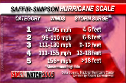
Hurricane: An intense tropical weather system of strong thunderstorms with a well-defined surface circulation and maximum sustained winds of 74 mph (64 kt) or higher.
-
A generic term for a low pressure system that generally forms in the tropics. It is often accompanied by thunderstorms and, in the Northern Hemisphere, a counterclockwise circulation of winds near the earth's surface.
-
-
Names for Hurricanes for 2005 Season: Arlene, Bret, Cindy, Dennis, Emily, Franklin, Gert, Harvey, Irene, Jose, Katrina, Lee, Maria, Nate, Ophelia, Philippe, Rita, Stan, Tammy, Vince, Wilma
Names alternate between male and female names
-
Names are recycled every 6 years unless retired due to substantial damage or death or for other special circumstances
-
Naming process adopted by an international committee in 1979
Storm Surge: Water that is pushed toward the shore by the force of the winds swirling around the storm.
Tornado: Rotating, funnel-shaped clouds that appear from thunderstorms.
Tornado winds can reach 300 miles per hour.
Tornadoes are most likely to occur in the right-front quadrant of the hurricane. However, they are also often found elsewhere embedded in feeder bands, well away from the center of the hurricane.
This web page is a formally validated HTML 4.01 document.
This web page accesses a formally validated Cascade Style Sheet (a.k.a. CSS).
COPYRIGHT 2004-2005 [BRYANT KORZENIEWSKI]